Fort Siloso: Fort Connaught No.2 Magazine

No.2 Gun Magazine
The No.2 Magazine and the area to the north of it has intrigued me ever since I first visited the fort. Despite this, I never got round to trying to make sense of it for many years. I find that I am left with unanswered questions. Maybe one day I'll get them.
All three Connaught gun emplacements, and those at Tekong are recorded as being of the same pattern. However, Aerial photos of Fort Connaught show the entrance to the No.2 magazine was differently oriented to the other two magazine entrances. Why was this?
 RIGHT: The orientation of the three magazine entrances
An answer may lie in the topography of the fort's location. The three guns lay along the line of a Saddle (a low point between two areas of higher ground). Alternatively, it may have been due to the layout of other structures in the fort.

ABOVE: A contoured map of the battery. There is a difference of 25 feet (7•6m) between the contour lines Despite the differences in contour levels, the guns were all constructed to a Trunnion Height of 125 Feet (38m) above mean sea level.
 I think that the difference is to do with a rectangular underground chamber that is between the gun emplacement and today’s Pyramid shelter for golfers. When I first saw the chamber, the top of it was visible, and I thought that it might have been the top of the Burster protecting the magazine, but it didn’t look right and the orientation was wrong. The magazine entrance would not have been in the correct place either. In addition, the measurements of the chamber do not match the size given on magazine plans. Note: The chamber is no longer visible due to a revamping of the golf course.
I concluded that the chamber was for a completely different purpose, and that it's location meant that the No.2 magazine had to be positioned differently. It could not have been the same orientation as the other magazines due to the location of the underground structure.
RIGHT: So, back to the aerial photo. I overlaid the correctly oriented magazine plan for the No.1 Gun on each emplacement on the aerial photo. No.s 1 & 3 magazine entrances matched nicely, but the No.2 did not. So a little thinking and flip the plan for the No.2 Magazine horizontally - hey presto, a fit. All that’s needed now is a little evidence that the No.2 was indeed flipped and not where the underground structure is. Back to aerial photos of the site.
 LEFT: An oblique aerial photo looking approximately south west, showing the No.2 Gun. The Magazine, the entrance stairs and the road are clearly visibly. The ventilation shafts of the magazine are where they should be if the magazine layout had been flipped as in the image above.

ABOVE: A plan of the magazine overlaid on an aerial photo. The entrance stairs align with the aerial photo and the magazine is a good fit for the location.


ABOVE LEFT: The top of the underground chamber before it was covered.
ABOVE RIGHT: The Magazine overlaid on a 2024 view of the area. There are no known remains of the Magazine
The Area to the North of the No.2 Emplacement
It is recorded that there was an underground Command Post at the fort. Map references put this some 94 yards (86m) north west from the No.2 Gun, placing it beyond the Pyramid shelter, and closer to the No.3 Gun than to the No.2. Assuming the map reference to be correct, the underground chamber cannot have been the Command Post.
Note: I have at least one map reference for Singapore defences that is incorrect. It places a building out to sea.

ABOVE LEFT: The area to the north of the No.2 Gun. The approximate location of the underground Command Post is shown, as is an underground area which I thought was the Engine Room. The roof of the underground chamber is easily seen.
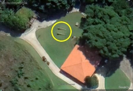
ABOVE RIGHT: Close to the Pyramid Shelter are two concrete walls (circled). These angle down into the ground.

 ABOVE: The two walls are on the right of the photo. In the centre of the photo is what could be the top of the escape shaft from the possible Engine Room.
RIGHT: The two walls disappearing into the ground. What possible purpose could they have served?
 LEFT: Purely a guess, but could the two walls be the start of a sloping passage leading to the underground chamber?
Which brings us to the chamber. Could it have been an artillery store or workshop, or indeed both? The fort would certainly have had both to store spare parts and for repairs to be carried out. The walls are far enough apart to allow trolleys and equipment to pass between.
Any entrance passage would have had a bend or turn in it. This to prevent splinters from bombs of shell exploding near the entrance from entering the chamber.
Hopefully one day I'll find the answer to this little mystery.